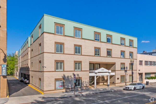
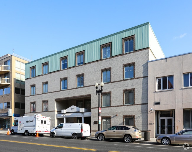
Property Record
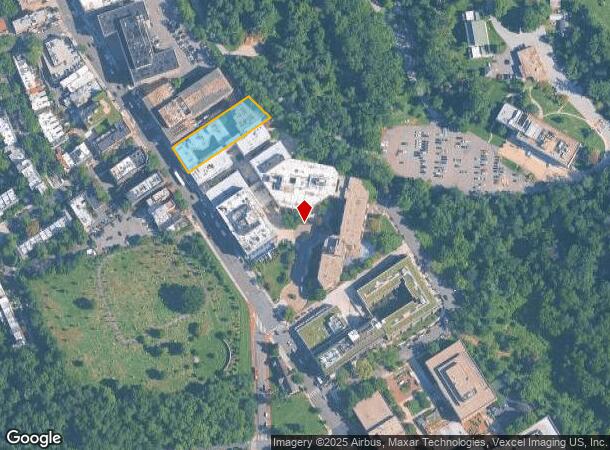
2141 Wisconsin Ave Nw, Washington, DC 20007
Current Lease Availabilities
NEARBY LISTINGS FOR SALE OR LEASE
Property Detail
2141 Wisconsin Ave Nw
Washington-Arlington-Alexandria, DC-VA-MD-WV
Observatory Circle
1299-2163
District of Columbia
Condominium
District of Columbia
X
0.01 AC
1100010012C
Glover Park
880 SF
Washington, DC
DEMOGRAPHICS near 2141 Wisconsin Ave Nw
1 Mile
3 Mile
5 Mile
2024 Total Population
24,615
298,450
718,517
2029 Population
22,051
274,838
675,473
Pop Growth 2024-2029
(10.42%)
(7.91%)
(5.99%)
Average Age
40
38
38
2024 Total Households
12,411
148,719
340,357
HH Growth 2024-2029
(11.32%)
(8.78%)
(6.58%)
Median Household Inc
$124,380
$122,165
$121,086
Avg Household Size
1.90
1.90
2.00
2024 Avg HH Vehicles
1.00
1.00
1.00
Median Home Value
$1,019,428
$878,890
$831,088
Median Year Built
1948
1959
1964
Nearby Places
- Restaurants
- Banks
- Shops
- Fitness
- Groceries
PUBLIC TRANSPORTATION
COMMUTER RAIL
4 (Fredericksburg Line - Virginia Railway Express, Manassas Line - Virginia Railway Express)
DRIVE
WALK
Distance
4 (Fredericksburg Line - Virginia Railway Express, Manassas Line - Virginia Railway Express)
9 min
4.2 mi
L'enfant (Fredericksburg Line - Virginia Railway Express, Manassas Line - Virginia Railway Express)
DRIVE
WALK
Distance
L'enfant (Fredericksburg Line - Virginia Railway Express, Manassas Line - Virginia Railway Express)
9 min
4.2 mi
AIRPORT
Ronald Reagan Washington Ntl
DRIVE
WALK
Distance
Ronald Reagan Washington Ntl
14 min
6.6 mi
Washington Dulles International
DRIVE
WALK
Distance
Washington Dulles International
42 min
26.3 mi
Baltimore/Washington International Thurgood Marshall
DRIVE
WALK
Distance
Baltimore/Washington International Thurgood Marshall
52 min
34.4 mi
Freight Ports
Port of Baltimore
DRIVE
WALK
Distance
Port of Baltimore
58 min
41.4 mi
Nearby Properties
Address
Land Use
TOTAL SIZE
Lot Size
Zoning
Address
Land Use
TOTAL SIZE
Lot Size
Zoning
2,300,000 SF
1.60 AC
D-5-R
Address
Land Use
TOTAL SIZE
Lot Size
Zoning
2,052,109 SF
90.60 AC
UNZONED
Address
Land Use
TOTAL SIZE
Lot Size
Zoning
533,778 SF
18.08 AC
UNZONED
Address
Land Use
TOTAL SIZE
Lot Size
Zoning
5,483 SF
88.76 AC
GOV
Address
Land Use
TOTAL SIZE
Lot Size
Zoning
142 AC
GOV
Address
Land Use
TOTAL SIZE
Lot Size
Zoning
2,493,936 SF
8.99 AC
UNZONED
Address
Land Use
TOTAL SIZE
Lot Size
Zoning
3.71 AC
UNZONED
Address
Land Use
TOTAL SIZE
Lot Size
Zoning
63.89 AC
GOV
Address
Land Use
TOTAL SIZE
Lot Size
Zoning
3,750,395 SF
10.82 AC
UNZONED
Address
Land Use
TOTAL SIZE
Lot Size
Zoning
262,673 SF
5.35 AC
D-7
Address
Land Use
TOTAL SIZE
Lot Size
Zoning
1,530,865 SF
6.05 AC
D-6;UNZONE
Address
Land Use
TOTAL SIZE
Lot Size
Zoning
42.57 AC
GOV
Address
Land Use
TOTAL SIZE
Lot Size
Zoning
2,455,000 SF
11.08 AC
MU-2
Address
Land Use
TOTAL SIZE
Lot Size
Zoning
52.44 AC
UNZONED
Address
Land Use
TOTAL SIZE
Lot Size
Zoning
1,100,000 SF
2.13 AC
D-6
Address
Land Use
TOTAL SIZE
Lot Size
Zoning
1,310,661 SF
3.38 AC
D-6
Address
Land Use
TOTAL SIZE
Lot Size
Zoning
1,738,573 SF
2.11 AC
D-7
Address
Land Use
TOTAL SIZE
Lot Size
Zoning
1,081,367 SF
6.46 AC
UNZONED
Address
Land Use
TOTAL SIZE
Lot Size
Zoning
1.57 AC
D-5
Address
Land Use
TOTAL SIZE
Lot Size
Zoning
1,015,833 SF
1.60 AC
D-7
Address
Land Use
TOTAL SIZE
Lot Size
Zoning
553,914 SF
55.91 AC
R-1B
Address
Land Use
TOTAL SIZE
Lot Size
Zoning
758,000 SF
2.22 AC
D-4-R;MU-7
Address
Land Use
TOTAL SIZE
Lot Size
Zoning
1,185,122 SF
2.43 AC
D-6
Address
Land Use
TOTAL SIZE
Lot Size
Zoning
4.95 AC
UNZONED
Address
Land Use
TOTAL SIZE
Lot Size
Zoning
1,562,988 SF
15.33 AC
MU-10;MU-9
Address
Land Use
TOTAL SIZE
Lot Size
Zoning
479,505 SF
5 AC
D-6-R
Address
Land Use
TOTAL SIZE
Lot Size
Zoning
1,214,044 SF
1.48 AC
D-6
Address
Land Use
TOTAL SIZE
Lot Size
Zoning
469,183 SF
1.20 AC
D-5
Address
Land Use
TOTAL SIZE
Lot Size
Zoning
900,000 SF
260 AC
S-3A
Address
Land Use
TOTAL SIZE
Lot Size
Zoning
626,543 SF
5.29 AC
UNZONED
The World's #1 Commercial Real Estate Marketplace
Connect with us
© 2025 CoStar Group
The information above has been obtained from sources believed reliable. While we do not doubt its accuracy we have not verified it and make no guarantee, warranty or representation about it. It is your responsibility to independently confirm its accuracy and completeness. Any projections, opinions, assumptions, or estimates used are for example only and do not represent the current or future performance of the property. The value of this transaction to you depends on tax and other factors which should be evaluated by your tax, financial, and legal advisors. You and your advisors should conduct a careful, independent investigation of the property to determine to your satisfaction the suitability of the property for your needs.